


REAL-TIME INTELLIGENCE FOR A COMMON OPERATING PICTURE
Today’s military personnel are often deployed in tactical settings – whether land, sea or air – with limited access to real-time intelligence data. This lack of efficient data movement severely limits the capability for situational awareness by both commands and operators, particularly in low-bandwidth situations, which are common in deployed operations.
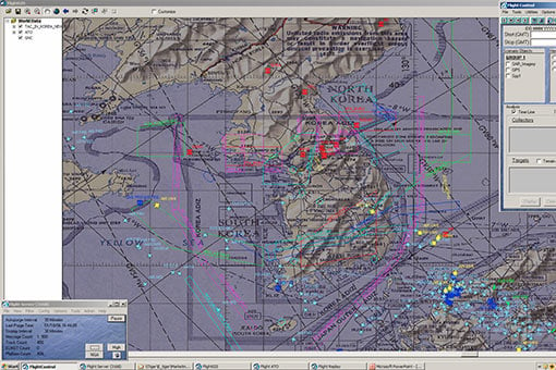
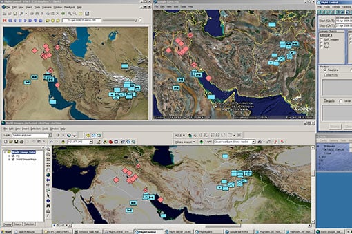
Simulyze’s Flight Control® solves this challenge with the only commercial off-the-shelf (COTS) application built on a true, advanced Operational Intelligence (OI) platform. A decision support tool for dominant battlespace management, analysis and alerting, Flight Control® integrates geospatial foundation information, such as maps and imagery, with critical operating planning data to provide a user-friendly geospatial interface, all in real-time.
Flight Control® was one of the first air, land and sea visualization tools for commanders, mission planners and analysts to see a complete and accurate picture of the battlespace and manage and analyze data within it. Today, Flight Control® is deployed worldwide.
Some of our first Flight Control® clients were the U.S. Air Force and an intelligence organization within the U.S. government, both of which were focused on building and advancing its technological and analytical data capabilities.
In the wake of the September 11, 2001 terrorist attacks, an unprecedented number of data streams began to be analyzed for actionable intelligence about national security threats, but analysts were not able to aggregate and format data into meaningful information. After Sept. 11, we helped the U.S. military and intelligence communities implement a new technology system that could receive, store, filter, manipulate and interpret massive amounts of data from external sources.
ADVANCED SCALABILITY, LOW-BANDWIDTH DELIVERY
Flight Control® ingests, interprets, processes, standardizes and fuses highly disparate data sources in real-time with a customizable graphical interface, providing unprecedented situational awareness and insight for complex mission operations. Enabling efficient data movement between an operator and command, Flight Control® accommodates both structured and unstructured data from a variety of sources, regardless of format or originating program. These sources can include: live mission data, weather conditions, imagery, video, RADINT, GPS coordinates and social media data, among others.
Flight Control®’s filtering of complex data and advanced processing and timing techniques prioritize data and allow transmission as low as 2400 baud. This provides both deployed personnel and the command with the information needed to make time-sensitive decisions.
With archival and replay capabilities, Flight Control® is a complete information management solution that also aids in training, post-operation analysis, incident investigations and reviews of operational effectiveness. Plus, its off-the-shelf delivery model makes integration more efficient and cost-effective.

COMMAND AND CONTROL
Contains a tool suite designed for the command and control of remote sensors within the common operating COP architecture

REAL-TIME PROCESSING
Built on a sophisticated OI platform, Flight Control® processes and presents data in real-time

Seamless data integration
Integrates data from a wide variety of sources, including sensory data, weather, Global Positioning System (GPS) tracking, social media data, video metadata, radar intelligence (RADINT), Unmanned Aerial Vehicle (UAV) data, databases, imagery, and signals intelligence (SIGINT)

ANALYTICS
Delivers a range of analytics, from simple calculations like distance and proximity, to complex terrain analysis including line of sight and intervisibility

ALERTING
Multiple customizable alerting functions including geo-fences, relative movement, position reports, and keywords

Highly scalable
Can be deployed in a variety of operational environments, ranging from enterprise server systems to a low-bandwidth single user

LOW-BANDWIDTH ENVIRONMENTS
Complex data filtering, advanced processing and timing techniques enable Mission Insight™ to prioritize data and allow transmission as low as 2400 baud, even in remote areas

TRUSTED SECURITY
Trusted to process, analyze and safeguard data vital to commercial operations and U.S. national security, including data residing on classified networks
