


TAKE FLIGHT WITH UNPRECEDENTED INSIGHT
An enterprise-level solution that integrates and visualizes all aspects of drone flight operations into a single interface.
As the commercial UAS industry begins to take flight in the U.S. and around the world, ensuring the safety of unmanned operations requires integration of vast amounts of disparate data that need to be displayed in a standardized, graphical format.
With manned flights, there are pilots, co-pilots, air traffic controls and various others to provide first hand accounts of the flights themselves, plus the instrumentation onboard the airliners. Drones, however, have a lack of data insight. While removing pilots and the accompanying instrumentation from UAS has enabled them to be lighter and smaller, it also removed feedback within the system needed for flight guidance. There is no ability for first-person obstacle avoidance without eyes in the pilot’s seat.
Mission Insight™ is built on Simulyze’s proprietary platform to provide UAS operators with a common operating picture (COP) by interpreting, standardizing and fusing highly disparate data sources in real-time with a customizable graphical interface.
Mission Insight™’s ease of use and deployment makes Mission Insight™ suitable for a wide range of drone operations, such as aerial photography and surveying, agriculture, construction, infrastructure and utilities inspection, emergency management, search and rescue, disaster recovery, and oil and gas exploration.
MISSION INSIGHT™ — PACKAGED IN-DEPTH DATA ANALYSIS
Simulyze offers a packaged commercial off-the-shelf (COTS) application built on its Operational Intelligence platform — Mission Insight™.
Mission Insight provides command and operators in deployed situations with a common operating picture, even in the most remote environments or low-bandwidth situations, to ensure real-time, in-depth data access for mission-critical events. Mission Insight interprets, standardizes and fuses highly disparate data sources in real-time with a customizable graphical interface, providing unprecedented situational awareness and insight for complex mission operations.
ADVANCED SCALABILITY, LOW-BANDWIDTH DELIVERY
Mission Insight’s advanced scalability and low-bandwidth delivery technology enables efficient data movement between the operator and command. Its complex data filtering, advanced processing and timing techniques enable Mission Insight to prioritize data and allow transmission as low as 2400 baud. This provides both the deployed operators and command with the information needed to make time-sensitive decisions.
Mission Insight gives users a complete information management solution, including archival and replay capabilities in addition to the correlation, fusion and analytical tools, aiding in training, post-operation analysis, incident investigation and review of operational effectiveness.
SENSORY DATA
ELINT
WEATHER
GPS TRACKING
SOCIAL MEDIA DATA
VIDEO METADATA
RADINT
UAV DATA
DATABASES
IMAGERY
SIGINT

HIGHLY SCALABLE
Can be deployed in a variety of operational environments, ranging from enterprise server systems to a low-bandwidth single user

LOW-BANDWIDTH ENVIRONMENTS
Unique to Mission Insight, data can be relayed across bandwidths as low as 2400 baud

REAL-TIME PROCESSING
Built on an Operational Intelligence platform, Mission Insight processes and presents data in real-time

ANALYTICS
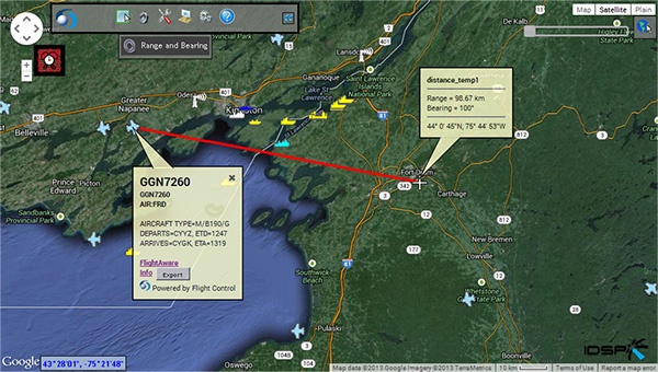
Delivers a range of analytics, from simple calculations like distance and proximity, to complex terrain analysis including line of sight and intervisibility

COMMAND AND CONTROL
Contains a tool suite designed for the command and control of remote sensors within the COP architecture

ALERTING
Multiple customizable alerting functions including geo-fences, relative movement, position reports, not report and keywords

TRUSTED SECURITY
Trusted to process, analyze and safeguard data vital to U.S. national security, including data residing on classified networks SIPRNet and JWICS
